Monday, July 30, 2012

Hadley Mountain

I have a homey summer house up in the Adirondacks on the Great Sacandaga Lake.  For years I've been traveling up there to take part in some relaxation and water sports, but it wasn't until last year that I decided to check-out the hiking available right by the house.  I set out on the trail of Hadley Mountain with my mom and one of my friends in September last year, only to have to turn around when it started to thunderstorm.  So, naturally, I decided to attempt it when I was up there last weekend, and again I brought a friend.  To get to the trail head from my house on North Lake Shore Road we turned left on Walter Maxfield Road and followed that all the way up until we hit Hadley Hill Road, on which we made a right.  From Hadley Hill Road you make a left on Tower Road, which is a dirt road surrounded by woods.  Last year I set out to find the trail head all on my lonesome on a foggy morning around 6 or so, and while driving on Tower Road I was sure I had made a wrong turn and was on someones private road and was surely on my way to getting shot.  Thank you Deliverance for making us all skeptical of small mountain town USA!  Needless to say, I found the trail head.  When on Tower Road it will come on your left.  There is a guest book you can sign into and pamphlets you can take (there were no more pamphlets let when we were there this time) as well as walking sticks people have left behind for others to use.  In an article I read in Adirondack Life magazine Hadley Mountains trail head was voted the most well maintained.
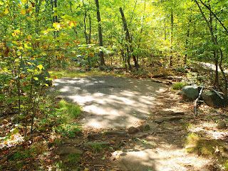
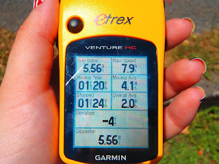
After signing the guest book we headed up the mountain.  Hadley Mountain is 2,654 feet and during the hike itself you gain 1,525 feet of elevation (I'm going off memory with these numbers from an article in Adirondack Life on the fire tower challenge-which is climbing 18 of the 23 mountains with fire towers on them in the Adirondacks.  Anyway, numbers may not be 100% spot on).  I can tell you now, however, that being a Bergen County girl who hikes Harriman, Bear Mountain, Storm King, Ramapo, and the Palisades that we don't have hikes like this around here.  At least I've never done any.  It's a short hike, two miles up and two miles down (since it's all one trail), but it's steep.  Also, the mountain had three significant fires in the early 1900s that it's still recovering from so there are a number points on the trail in which you are walking directly on the rock of the mountain.  The soil was compromised from fires and never recovered in these sections.  


I won't even try to fake that the incline didn't kick our butts.  We were definitely huffing and puffing our way up this mountain.  We passed a family that was on their way down and asked how much longer to the top and the wife said 30 minutes and we must have exhaled hard or something to show the exhaustion that we were experience and her husband said "Yea I know.  The first section is really hard right?  It just brings you straight up".  I grasped onto what he said because that meant that there was a second section that wasn't so hard!  We did eventually reach the second section which flattens out a bit and offers some beautiful views.


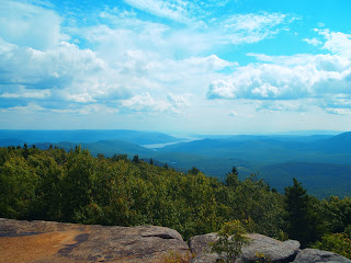
The next person we talked to was our guardian angel.  This gorgeous little cherub looking blonde little girl who said "You're almost there!" when we passed her.  Our savior!  As we continued climbing I realized, however, that children have no perception of time or distance.  Finally, we got to the top.  Before you get to the summit there is a house to the right that was the ranger house back when the fire tower was first opened.  The house stopped being used in 1990 and then was reopened in 1996 and is staffed in the summers, though no one was there when we were snooping around outside of it.  The fire tower is sturdy and can be climbed, however, you don't have  to climb it to get great views.  From the summit it's just a 360 of a gorgeous mountain range, endless sky, and the Great Sacandaga Lake.  


  From the summit there is a little trail that leads to a small open area with a few small cairns (which the children we passed were calling rock animals) and a fire pit made of rocks.  My friend relaxed on the summit while I wandered on that trail. On my way back to the summit there was a rock step that had a piece of bark under it, which looked out of place to me.  I pulled the bark away and, low and behold, I had found a geocache!  Never before have I found one without coordinates, and I've definitely never found one when not even looking for one.  I was so psyched!  I ran back to the summit of the mountain, almost knocked two people over even, and screamed "Guess what I found? Guess what I found?" to my friend that was maxing relaxing Huckleberry Finn style.  He replied "Who died?" and I grabbed my hiking pack and said "A Geocache!  Come with me!".  As it turns out, he didn't even know what a geocache was so double fun there.


I was SO excited about this cache that I even spelt my geocaching name wrong.  Shrugs!  I definitely am going to do this hike again.  The views are just too beautiful and I want to share them with just about anyone that is willing to take the trek.  Next time, I'm definitely going to look at geocaching.com so I can find all the caches hidden amongst the mountains!


Sunday, July 29, 2012

A Walk Through the Past

I went hiking...again, but this time with another person!  Unheard of, I know.  Last time I brought her on my favorite trail on the Palisades Cliffs, the Giant Stairs, she made us turn around so I decided to do an easier trail-the Shore Trail.  We parked at the Ross Dock picnic area and set off on our hike.  I had looked up a few geocaches along the cliffs to see if I could give her her first geocache experience, but we didn't find any that I hadn't found before.  Admittedly, after looking for the first one and not finding it, we kind of gave up on looking for any of the other ones.  The Shore Trail runs from Fort Lee to the Long Path near the Stateline Lookout.  It is, with like two exceptions, flat and simply follows the river.  Along the way, however, you get to see parts of what the Palisades used to be like back in the 30s when people actually dared to swim in the Hudson River.

I've said it before and I'll say it again, the history of the Palisades is one of the reasons I love hiking it so much.  We came across a sign explaining the beach we were staring at, Bloomer's Beach, and the bath house that still stands-sans anything, but the stone that it's made of.  We continued on along the river.   We eventually came upon another bath house, which excited the history dork in me.  I was never much of a History student.  Reading about it doesn't do anything for me, but put me in an old building where my mind can trying grasping the concept of just how many people have been in there and what their stories are and I'm in heaven!  My ability of letting my mind run away with itself can work against me as well, like when I see an old man eating alone in the diner and I come up with this sad story about his family being killed and him being the sole survivor.  Ridiculous!
Aside from old buildings, we also saw a good number of dead fish along the trail.  I was perplexed by this because I took this hike on July 16th and there hadn't been any big storms or any other reason for the Hudson River to get high enough to reach the Shore Trail, abandoning fish on land when it went back to low tide.  So, I have no clue why we found five or six dead fish along the way on the trail, but I dedicate this blog to them.  Because I like loop hikes and all, we ended up walking back on River Drive.  My friend, who hadn't been hiking in awhile, quit right at the top of the drive down to the parking area.  She told me to get the car and pick her up...which I did.  While the hike, for me, was pretty unexciting-too flat to even feel like hiking, more like walking the mall...only prettier-it was long.  My friends foot was hurting her after the hike, and still a week after, so bad that she ended up going to the doctor.  Luckily, she'll live.  Got me to thinking that maybe I should open "Elyse's boot camp" in which I kick people's butts into shape just by making them hike with me (as if I'm so in shape and all).


Saturday, July 14, 2012

Hiking and Biking at Nyack Beach State Park

I parked at the entrance of Nyack Beach State Park for $6 and started off my hike by following the bike path.  It's a lovely gravel path between the ridiculously high cliffs of the Palisades and the glistening water of the Hudson (if only the water wasn't so disgusting).
Along the path there are picnic tables and bar-b-ques so definitely a place I would recommend for a picnic day.  When I reached a hill on the bike path I continued up and came across part of an old building.  As someone who loves finding such things in the woods I, naturally, snapped a bunch of pictures.  The building had what looked like raspberry bushes growing out of it, but I won't pretend to know anything about fauna and vegetation.  If I was Alex Supertramp, otherwise known as Chris McCandless (from Into the Wild), I would have eaten the wrong plant, or part of a plant, long before he did and met the same terrible fate.  I enjoy all of nature, but I know nothing about most of it.  Sad, really.   
Anyway, I continued on my way and when I came to a Y in the path I went right.  On this trail I came across a few more foundations of buildings, but I also realized I was just following the river and not ascending the cliff at all, so the first opportunity I had to go left I did.  This brought me up to where I would have gone had I taken a left at the Y.  Right when I came out on the Landing Road (which is no a usable road-much like Old 9w by Stateline Lookout on the Palisades) there was a male deer stare straight at me from the woods.  I snapped a few pictures of him and his antlers and continued on my way.  From there I turned off the road onto the Long Path and FINALLY got into the woods.  Before I entered, however, I stopped to read an informative plaque. 
So that explains the buildings I had seen, and would continue to see.  As I made my way on the Long Path I realized that I had already taken this trail in the past, only from the other side of Hook Mountain.  That was about three or four years ago and it was in March so this July hike was a bit different.  It was simple enough, except for the lack of coverage once you reach the top.  Unfortunately it was a very sunny and hot day and I was sweating away at the top of the mountain.  Luckily, however, there are gorgeous views to make it worth it.
After the beautiful views you can turn off the Long Path onto the Yellow to parking on 9w (which is where I parked last time I did Hook Mountain), but this time I continued on the Long Path until I met the White path.  You are literally right next to, and a little bit under, 9w for a little bit before you reach the White trail.  I made a left onto White and pretty much walked in a thin section of woods between houses.  I came out of the woods onto North Midland Ave and turned left to follow the road.  The Marydell Life and Faith Center was on my left.  
North Midland Ave brought me to North Broadway which I made a left on and the entrance to Nyack Beach State Park was right there.  There are some gorgeous, huge, and crazy expensive houses along that road which I took some pictures of and convinced myself I would one day buy...ya know, when I'm a millionaire.  Sighhhhhh.  

And then I grabbed my bike out of my trunk and took an enjoyable bike ride along the Hudson only to go home and go swimming.  I had my very own triathlon! 


Wednesday, July 4, 2012

Simply Enjoyable

I once again set off into the woods this week.  This time around it was a loop in the Southern part of Harriman State Park.  The plan had been to park on Johnsontown Road in Sloatsburg, NY, but, of course, they were doing construction or some sort of something so I couldn't get all the way down that road to get to the parking lot I had originally planned on.  I turned off Johnsontown Road back onto Seven Lakes Drive and parked across the Visitor Center.  My plan had been to finally check out some of the mines that are throughout Harriman, and while I didn't have to change my loop too much due to the detoured parking, but I decided to save the mine exploring for another time.  I began on the red trail from the parking lot of the Visitor Center.  This is a trail I have taken many times and the last time I was on it was during a very bad time in my life so I wasn't too thrilled to be back on it, but it's been about three years so I decided to embrace and just be grateful I was back in the woods.  When I came to a fork in the road I veered left to begin the Yellow trail.

I was only on the Yellow trail for a short while because, in my modified hike, I decided to check out the Dutch Doctor Shelter.  From the Yellow trail I turned left onto the White trail.  After crossing over a stream that used to have a bridge, but currently did not (the minute I started on the Red trail there was a sign that said "BRIDGE OUT at STREAM CROSSING-PLEASE USE CAUTION" so hats off to the trail conference for being aware of these things) I came across what looked like, possibly, the foundation of an old home.  I checked my map and saw no point of interested dot, but stopped to admire it and take some pictures anyway.  History like that, in the middle of the woods, always amazes me.  It's one of the reasons I love the Palisades Cliffs-if you don't know about Cliff Dale first look it up and next go off into the woods on the Palisades and see the remnants of this once beautiful estate.  It all blows my mind!  Another reason I want to take a kayaking/walking tour of Bannerman Castle (again, if you don't know, look it up!).  The white trail crosses Seven Lakes Drive and then disappears back into the woods on the other side, at which point I headed right on the White trail.  The Red and White trails merge for a bit and then split off, and I was so content just traipsing through the woods that I almost missed where they separate, but luckily I didn't and I continued on the White trail toward Dutch Doctor.  It's your classic stone lean-to.  No breath taking views, but a nice place to rest your head.


From Dutch Doctor I continued on the White trail until I came to the Blue trail, otherwise known as the Victory trail at this point.  This trail was marked with a white square with a blue V.  I looked at the back of the map to see if it had any history on why this particular trail was called the Victory trail, but found no such information.  My one complaint about this trail is....telephone poles.  I was walking along enjoying nature and then I see a telephone..and another...and another...and you get the point.  A whole role of telephone poles just running right next to the trail, and the telephone wires were pretty low so it wasn't even as if I could ignore it.  I think that telephone poles should no longer exist and we should all just use cellphones, but then we have to deal with cell towers.  Lets just go back to smoke signals!  From the Victory trail I turned left on the Red trail, which passes Black Ash Mine, but since I had already decided to save the mines from another day I didn't even keep my eyes out for it.  There are underground pipelines running throughout the woods so numerous times along this hike I came to random clearing, which I was prepared for having hiked from the Visitor Center before. 

As I continued on the Red trail I came across a young deer.  We stared at each other and I, of course, snapped some pictures.  I began walking away and heard leaves rustling behind me so I turned around to investigate and the deer was following me!  No one ever taught me what to do in the instance of a baby deer approaching you.  I obviously wasn't scared that it was going to hurt me, but I also know that it's not a good thing to have wild animals too used to people so I snapped a few more pictures and then RAN! 

The Red trail leads to some road, which seems funny because I felt like I was out there in the woods and then there I was standing at the edge of a road, so I turned left on the White trail to continue on my way in the woods. I came across two old rusted out cars because what better place to dispose of your old car then in Harriman State Park, really?  The White trail led me all the way back to Seven Lakes Drive and I finished my hike up by walking on the road for about 3/4s of a mile.  As I've said before, I love loop hikes...which means that I hate having to walk the same part of a trail in a hike which is why I opted to finish up with Seven Lakes Drive.  If anyone has ever driven in Harriman then you know that the street is pretty darn beautiful too.  This hike, as the title explains, was simply enjoyable.  It was 8 miles on a 90 degree day and I never felt too hot, never considered giving up, never needed  rest.  There were no stunning views, nothing extra spectacular, it was just a simply enjoyable walk through the woods. 


Sunday, July 1, 2012

Excuse me while I jump off this cliff

For me, nature has always acted as a respite.  Even when I was little and I'd get in a fight with my mom or my brother or sister I would run off into the woods behind our house and disappear for however long was necessary.  As I've grown this need, this desire really, has only grown with me.  So it makes perfect sense that now, a newly unemployed me (after 9 years of employment), would want nothing more then to venture into the woods and never come out.  What better, really, then to do so (if you are an adult, and a logical one at that, this is the point where you should be thinking that applying for jobs and bulking up my resume would be a much better, and more mature, idea-and to you I say, blah!).  So again, I set off into the woods on Thursday to disappear for just a little while.  This time around it was Harriman State Park/Bear Mountain. I parked at the Anothony Wayne Recreation Area right off of the Palisades Interstate Parkway.  A very conveniently located and easy to find parking lot.  While I sat in my car trying to figure out some sort of poorly pieced together loop hike, as I always do (so prepared), a man came up to my window and asked where he should start.  I gave him a few options: White to Blue, White to Fawn, just White-and wished him the best.  When I finally made my way out of my car he was still there with his daughter, who I'm guessing was about five, and he asked if I'd like to hike with them.  I made up some excuse about not yet knowing which trails I was going on and he said "It's always nice to hike with company", which, I must say, I vehemently disagree with...not to mention that in that one sentence he discounted his poor daughter as company i.e. a person.  At this point I took matters into my own hands and told him, kindly, that I prefer hiking alone.  Out there alone in the woods all I need is the sound of nature, my footsteps, and my heavy breathing (plus some iPod action never hurt).  He went off on his way and I set off on mine.  I began by crossing the street on which you drive into the recreation area and setting forth on the bike trail (note: I went the complete opposite way of the man I had talked to.  I never claimed to be a social being) which quickly leads to the white trail.  When I came to an intersection, which consisted of the White trail, Beechy Bottom Road (a mountain bike trail/woods road), and the Fawn trail, I naturally chose the Fawn trail (as any right minded animal lover would).  While traveling on this trail, which is marked with white squares with a red 'F' on them (because it's part of the Red trail), I discovered that it was improperly named and should really be renamed as the Fern trail.  There were ferns in every direction!

I quickly turned off the Fawn trail onto the Blue trail to begin my poorly mapped out loop hike.  On the trail map (map 119 of the NewYork-New Jersey trail conference) this trail is marked with two stars representing two scenic views.  They certainly do deliver, and I'd even argue that there are many more then just those two, but perhaps as an outdoors lover I'm a bit biased.  At one point I reached a particularly beautiful spot, in my opinion (I can't give you anyone else's), and I'm standing at the top of the mountain with my iPod blasting  shaking my head at just how spectacular it all is only to turn around and see that my friend from the parking lot and his daughter are sitting behind me in the shade enjoying nice juicy, refreshing clementines.  I said hi, probably louder then anyone ever should due to my headphones being jammed in my ears and my music blaring, and quickly hurried away, a bit embarrassed for having been caught in my private moment of appreciation for nature and all the pure goodness it is able to supply a nobody like me.
The Blue trail transitions into the Blue and White trail so I was able to continue on my way on West Mountain.  I had originally been planning on turning left onto the Yellow trail and going all the way up that until it meets with the White trail, but when I looked at my map more diligently I noticed that if I stayed on the Blue trail I would be blessed with experiencing one of Harriman's lean-tos.  As someone who has backpacked Harriman, and seen four of the parks wonderful lean-tos (some more wonderful then the others) I decided this was something I was interested in.  So instead of turning onto the Yellow trail I continued on the Blue trail (which is to the left when the Blue and White trails split) and continued on to West Mountain Shelter.  On my way to the shelter I came across a deer who was munching on some plants directly on the trail.  When she saw me she began following the trail so it was as if we were hiking together.  Not so far down the trail she turned off to drink some lovely, and very refreshing, swamp water.  Now, about the West Mountain Shelter, all I have to say is I love how many people don't know, or care to find, these gems hidden in the woods.  West Mountain Shelter has a view that many people would pay good money for, and here it is in the woods...for free.  Seeing as I was hiking on a 90 degree I decided to turn off my hiking GPS and take a short break in the shade of this great place!


It was soon after enjoying this short break at the shelter I realized that this hike may not have been the best plan on this particular day.  It was hot out and I had some place I needed to be at 5.  I continued following the Blue trail until I reached the Red Trail (Red cross) which I knew I needed to make a left on to complete the loop as originally planned), but I was feeling all sorts of backwards and even after making the turn, and religiously checking my trail GPS to make sure that the shape that was being recorded resembled the loop I was going for, I was starting to get nervous.  I had to scale some rocks, which normally I would find totally enjoyable, but at this particular time on this particular day I was sure I was going to die.  My calves started aching and the water from my water pack has never taste better as I continued on my trek.  I got confused (I never claimed to be an expert) when I came across an intersection between the Blue and Red trail, because I thought I was further along the trail then where the map showed they crossed, but I successfully carried on.  Then I came to a four way intersection: behind me was the red trail, in front of me was the red trail, to the right was the red trail, and to the left was the red trail.  My sense of direction, at this point at least, was still pretty good so I knew I just had to turn left and follow wherever the trail lead me.  To the left was the 1777 trail which, had I read the back of the map before I was on it seeing all these historical plaques, I would have known was one of the Revolutionary Trails retracing the steps of the British and American troops during the Revolutionary War.  1777 was a very cool, easy, and educational trail. 
As I'm happily continuing on the 1777 I come up to a post that looks like it should have a sign on it, but, just my luck, instead it has a note which reads "Vandals have removed the 'you are here' map" and then explains which way to go at the intersection I'm standing at, which would be great except, of course, Anthony Wayne Recreation Area isn't listed on this note!  So, using my map and trying to figure out the fastest and shortest way to race back to my car (at this point it's 4 and once I get to my car I'm still a half hour from home and, oh yea, I need to be somewhere in an hour!) and choose the Doodletown Bridle Path that is to my left.  Doodletown, interestingly enough, was the site of a quaint little hamlet back in 1762, and while it's popularity increased over the next two hundred years, by 1965 the state had bought all the houses and let nature take its course...or something like that.  Of course the Doodletown Bridle Path has no markers and I start coming across what looks like trails, but when I turn onto them and find that they too have no markers I get nervous and become totally lost and backwards and try heading back in the direction I had come from.  Eventually I find Brown markers...only there's no Brown trail and as I continue on this steep rock climbing trail I study the markers more and more and realize that, perhaps, they're not Brown markers at all, but instead Brown spray paint used to cover up White markers because trails do get switched and rerouted!  I've scaled too many rocks to climb down though and decide that I'm just going to keep pushing.  It's around this time that I decide if I come to the top of the mountain and am able to see my car at the bottom of the cliff I am going to somehow figure out a way to successfully climb/ricochet/jump off to get to the parking lot and FINALLY get home (thoughts like this may be why both my mother and boyfriend worry about me hiking alone, however, in my defense, I make paracord bracelets and I just happened to be wearing a cobra stitch one.  That gave me at least 8 feet of cord to work with so my plan was, if you think about it, totally logical!).  I never do get to the top of the mountain, and my camera dies, but I keep trucking on and eventually I stumble upon the White trail  ::deep sigh of relief:: and from that point all I had to do was retrace my steps back down the fawn trail and right on over to the parking lot.  So the hike, which I had thought would take be 3 hours or so, ended up taking me five hours and I was a half hour late for what I needed to do, but didn't someone important once say "It's the journey that matters, not the destination" or some sort of rambling like that...which was obviously said by someone who never got lost in the woods in 90 degree heat.  In all reality though two of my favorite quotes are "Lost in the woods with no need to be rescued" (seen on a shirt at Kittatinny Campgrounds in Barryville, NY...which everyone should go to...only not when I'm there) and "Do not go where the path may lead, go instead where there is no path and leave a trail" said by the great Ralph Waldo Emerson. 
Zen


Friday, June 29, 2012

Storm King State Park....Sort Of


I visited Storm King State Park for the first time ever this week.  Having visited the Palisades Cliffs two days earlier and discovering my favorite trail, the Giant Stairs, was closed I decided it was time to expand my horizons.  After looking up a number of state parks within an hour of my town I decided to take Storm King State Park by storm-haha.  I parked at the second parking area on 9w once you've entered the park (near Butter Hill).  The view from the parking area was gorgeous so I was immediately excited to begin the hike.  While I brought a map (Trail Map 113 of the New York-New Jersey Trail Conference) I hadn't really figured out what route I would take.  I have always been more of a fan of loop hikes, as opposed to just taking one trail to a destination and back.  There is just so much beauty out there and by doing loop hikes I feel that you get to experience more of it.  From the parking area I headed out on the Orange trail.  This trail pretty immediately brings you to great views, but as I said the parking area was gorgeous so that was no surprise.  You're quickly high above both the curvy Palisades Parkway and the glistening Hudson River.  The latter being my favorite part.  While I appreciate hiking as a whole, I always enjoy a hike with water views more.   

Once I reached the end of the Orange trail I turned left on the Yellow/Highlands trail.  The Highlands trail is a trail being created by the wonderful people that make up the New York-New Jersey Trail Conference.  When completed, it will stretch from Connecticut through New York and New Jersey and end in Pennsylvania.       
While on this trail I came across a project adventure type course, which I thought was very strange in the middle of the woods.  As I continued walking I discovered that I was in fact right at the edge of the woods and I came out of the woods onto a dead end street.  Trail markers still appear and provide you with the information you need to get back into the woods.  I passed the Storm King School, a private school founded in 1867, and then turned left on the next street as the trail markers indicate.  From here I walked through a one lane tunnel, after letting a car pass through, and continued on my way. 

Next up was Black Rock Forest, an entirely different park that I hadn't really planned on going to, but when you don't really plan out a route you wind up places you hadn't really expected.  


I continued on the Yellow/Highlands trail, which is across the street from the parking lot in which this sign stands.  This trail leads to the Upper Reservoir.  After walking around the reservoir, and once again enjoying some water views, I broke off from the Yellow trail and turned onto the Blue Trail.  This is a woods trail that passes closely to a parking lot by the Forest Lodge and Science Center.  There is a small wooden bridge that crosses over a small stream and soon after that I came upon the Red trail.  I took a right on the Red trail, leaving the Blue trail behind, and wound up back in the parking lot with the Black Rock Forest sign.  I followed Reservoir Road, the road with the one lane tunnel on it, and made my way back into Storm King State Park.  I got back onto the Yellow/Highlands trail in Storm King State Park and followed it all the way up Storm King Mountain, which proved to have some breathtaking views.  From there I could see Bear Mountain Bridge and Bannerman Castle on Pollepel Island.    


From the Yellow/Highlands trail I broke off onto the White Trail which came up on my left.  The White Trail acts as a by-pass between Yellow/Highlands trail and the Blue Trail.  I was on the Blue trail for a short while before turning off onto an unmaintained woods road, which lead me right back to the parking lot.  The hike was a total of 6.75 miles and, as usually happens on new hikes for me, I was stopped more then I was moving because I was so busy taking pictures and letting the greatness of it all sink in  Another hike over.  I enjoy hiking so much that each time I walk out of the woods and finish up another hike a little part of me is disappointed.  I hate having to walk away from all that beauty.